Category: Traffic (Page 1 of 2)

What do you want Strathbungo to look like?

You might have noticed the consultation on the neighbouring Langside, Battlefield, Mount Florida, King’s Park & Toryglen Liveable Neighbourhoods. This year it is likely to be the turn of Strathbungo and Shawlands to be consulted in this way as the Glasgow City Council works its way across the city. This is a key opportunity to tell the council what the current problems are and what our hopes and dreams for the future of Strathbungo and the surrounding area are.

If we submit our best ideas, some of them might get funded and there is also the possibility that this consultation could lead to a Local Place Plan. This would give the agreed hopes and dreams of residents the full force of planning law and so bring them about through future developments.

While this consultation is still unconfirmed and months away, the time to get thinking is now. What do you want fixed? What do you want to change? What do you want to keep? How can we build an even better Strathbungo?

Crossmyloof Active Travel Path – Council Response

For those who read about the idea of a walking and cycling path behind the Crossmyloof Resource Centre, to provide a direct route from Moray Place to Crossmyloof Station, here is the response from the relevant Council department.

The original proposal and comments from the community are in the earlier post, Active Travel in Strathbungo – The Crossmyloof Resource Centre path

OFFICIAL

MESSAGE SENT ON BEHALF OF
PROPERTY & LAND SERVICES

Dear Councillor

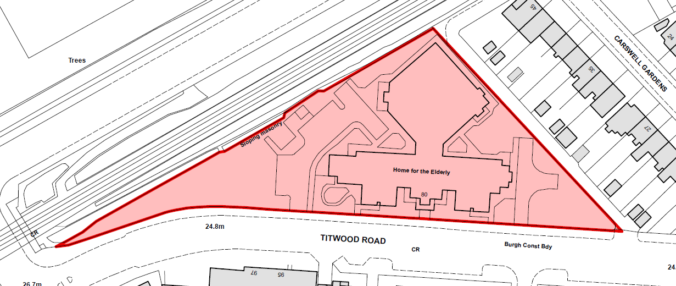
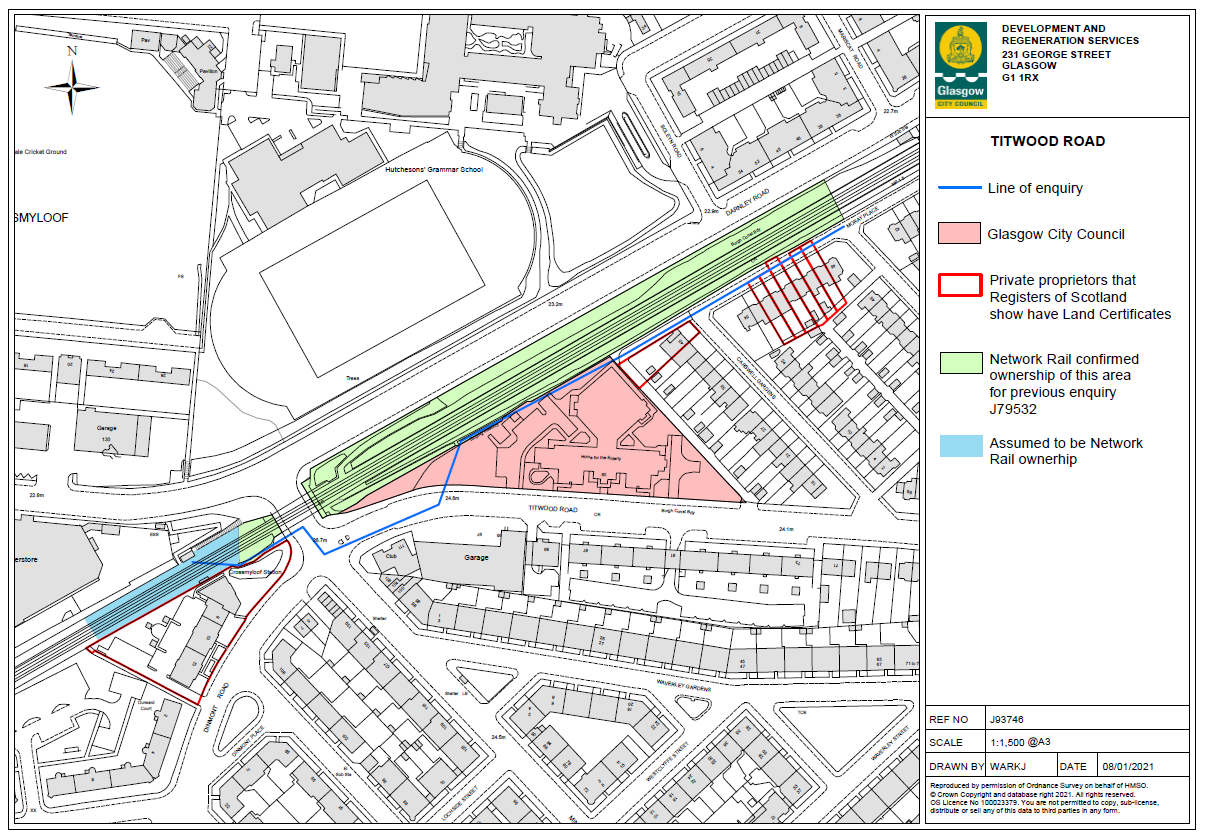
I refer to the enquiry received regarding the creation of an active travel path along the route of the rail line at Crossmyloof and traversing across the north of the site of the former care home (please refer to the attached plans).

On the face of it, the proposal would appear to have some merit. While there is existing access for pedestrian and cycles from Moray Place to the intersection of Titwood Road and Minard Road by means of turning left into Carswell Gardens and then turning right into Titwood Road, a path across the back of the care home site would be more direct and would shorten the journey. It would also be in line with Council policy on promoting Active Travel. However it would also inevitably mean a reduction in the likely capital receipt for the sale of the former care home and the investigation into the planning and viability of the path would also likely cause delay in securing a sale. While it is not possible to quantify how much the reduction might be, or what delay may occur, I think it fair to say that there would undoubtedly be some reduction in the capital receipt.

In addition, the proposed route of the path uses the lane to the north of 45 Carswell Gardens. This lane is in private ownership and is not adopted. Therefore in order to use the section of lane to the north of 45 Carswell Gardens for the Active Travel Route we would need to obtain permission of the owner of the land including permission to remove the section of wall. It is also very likely that the owners of the houses on the western side of Carswell Gardens that back on to the lane will have vehicular access rights to use the lane including the section to the north of 45 Carswell Gardens. If we were looking to restrict cars from using that section of the lane then agreement would need to be reached with each of the individual house owners on that point. Such a restriction would make it awkward for vehicles to get in and out and would likely lead to cars reversing onto Titwood Road. If a restriction on cars wasn’t required we would need to consider a path design that would accommodate both pedestrian and car users.

Clearly there are a number of issues that would need to be addressed in order to make the proposed Active Travel Route a reality. In addressing those issues there are no guarantees that agreement could be reached with either the landowner of the lane or the individual house owners, or that the terms, if offered, by the different parties would be acceptable to the Council. I would also add that the Council is committed to the development of a city-wide Active Travel Strategy which will deliver a strategic plan for Glasgow. A recruitment process is currently underway to undertake the development of this plan over the next 12 months. In advance of this, it may be premature to deliver stand-alone projects which may not necessarily fit with this city-wide strategy.

In conclusion, while recognising that the proposal has some merit, on balance we do not feel that this option should be pursued given the reduced capital receipt for the sale of the former care home; the cost of reaching agreement with the lane owner and possibly the housed holders; the amount of officers time required to negotiate and reach agreement with the various parties; the possibility that such work would be abortive should no agreement be reached; and also the development of the city-wide Active Travel Strategy may identify an alternative or more strategic active travel proposal for this locality which could negate the need for this proposed intervention.

Yours sincerely

Map of resource centre

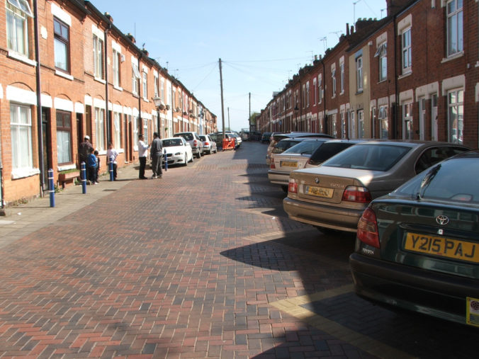
Council map of Crossmyloof Resource Centre Site with path overlaid in blue

The response included these maps. The blue line is an exact reproduction from my sketch, and was apparently initially taken literally by the officers, who objected to it bisecting the site.

Cllr Jon Molyneux plans to go back to the council officer for clarification of some of the points raised. He, like I, feels this reads like a contrived excuse to do nothing.

What do you think? Feel free to add your comments on the council response, and in favour or against the idea of a path.

Bike Hangars are coming…

The Glasgow Times today announced that the Council are finally going ahead with plans for bike storage lockers, including in our neighbourhood.

Streets will include amongst others

  • 48 Waverley Street
  • 4 Nithsdale Road
  • 95 Nithsdale Drive
  • 16 Kildrostan Street
  • 2 Balvicar Drive
  • Balvicar St/Pollokshaws Road

More details in the Glasgow Times article.

Don’t see anything on the council website about it though.

Active Travel in Strathbungo – The Crossmyloof Resource Centre path

Here’s a New Year thought.

The triangle of land behind Carswell Gardens used to be a Corporation depot & yard, but more recently was used for the Crossmyloof Resource Centre & old folks home. That has now closed, as it is considered surplus to requiremetns, and the Council is putting the site up for sale. It is likely to be bought by a developer for housing, which could in itself have significant impact on Strathbungo, although apparently care home operators may also be interested. We will have to watch this space.

Meanwhile however it also presents an unusual opportunity. The Council has the ability to reserve a strip of land alongside the railway fence extending directly from Moray Place to the end of Titwood Road, and so provide a traffic free path for walkers and those on bikes to get quickly and safely to Crossmyloof Station and Morrisons’ supermarket.
Continue reading

Greening Strathbungo

image of tree

Thank you to the Strathbungo Eco Group, which presented on a variety of topics at the Society’s AGM on Tuesday 17 November.

The group was formed by a group of Bungo neighbours, inspired by cleaner air and audible birdsong during lock-down. There is a variety of projects under way, ranging from the practical to the exploratory. You can find out more from the slides that were presented here.

If you’re interested in being part of this informal but enthusiastic group, email strathbungoecogroup@gmail.com to request to join the WhatsApp group.

The planning application for a new car park in Pollok Country Park

On 27th May Glasgow City Council applied for planning permission to itself for a new car park, road and footpath as part of the Transforming Pollok Country Park Project (see here for planning papers) and in anticipation of higher visitor numbers to the Burrell once the refurbishment/expansion is complete.

Key: blue = existing road upgraded; black = new road; brown = new footpath;  light blue – existing footpath upgraded to disability standards.  All illustrations courtesy of GCC Planning Portal.

The application form is not entirely clear but planning consent appears to being applied for:

  • a new car park for 277 vehicles on the existing unused Nether Pollok blaes pitch by Hagg’s Road
  • widening of the Hagg’s Road exit to form an entrance/exit
  • creation of a new road to the Burrell car park and
  • installation of various car barriers to limit vehicular access elsewhere in the Park.

The application is open for comment until 6th July and you can do so on the online planning portal above or at end of this blog.

The declared purpose of the application is to reduce the circulation of traffic in Pollok Country Park.  It is part of a wider active travel plan accompanying the re-development of the Burrell.  The Application contains a report of Glasgow City Council’s engagement with stakeholders that took place in 2019.   Since then, as a result of Covid-19, the world and Pollok Country Park have changed beyond recognition.

More specifically the closure of Pollok Park to vehicles during the lockdown and the large numbers of people accessing the park by foot or by bike has transformed ideas of what might be possible.  The proposals now look very dated and it is regrettable that Glasgow City Council has not re-considered them before submitting the planning application.

Continue reading

South West City cycle way extension – is this the best route?

c

If interested but unable to go to the drop-in you can access the online consultation here

The proposed route extends the current South West City Way from the Shields Rd/St Andrew’s Drive junction along St Andrew’s Drive to Pollok Park.

The proposed route bypasses the main centres of population in East Pollokshields and Strathbungo.  Were it instead to continue up Shields Rd to Nithsdale Rd, then on to Terregles Ave joining St Andrew’s Drive after Maxwell Park, it would be almost the same distance and much more helpful to any local resident wanting to use a dedicated cycle lane to get to Pollok Park or into the city centre by the South West Cycle route.    The Strathbungo Society could then work on the missing link between the Darnley/Nithsdale and Shields/Nithsdale junctions!

What do people think?

Parking in Strathbungo

The adverse effect of traffic on the comfort and safety of the residents in this area has the same root cause as in any other urban area, i.e. too many vehicles in too small a space. However, the problem is aggravated in Strathbungo in that the streets were not designed to carry through traffic or fast traffic, or to be used for parking. The older streets, Regent Park Square, Queen Square, Marywood Square and the northern half of Moray Place were built on a scale adequate for access to the houses by horse and carriage. The result is we have an area which is totally unsuitable for the unrestricted use of motor vehicles, whether belonging to residents or to anyone else.

So said the Strathbungo Society in their fact finding report in 1972. It’s a common theme in Strathbungo that the concerns of today are little different from those of yesterday, but it has been brought into focus by this week’s announcement of legislation to ban pavement parking in Scotland. What effect will this have on Strathbungo? Will we need to ask for an exemption, or is this the very thing we have been waiting for?

In 1972 the Society conducted a survey of the numbers of cars and commercial vehicles parked in Strathbungo overnight, There is nothing like hard data to base a discussion on, and so I couldn’t miss the opportunity to repeat it. This is what they, and I, found.

Continue reading

A Woonerf in Strathbungo

Statement from The Strathbungo Society Committee

Traffic and parking in Strathbungo present a problem of ever increasing severity; recently we have been informally advised that it will soon be necessary to restrict parking in Regent Park, Queen and Marywood Squares to a single side in order to allow access for emergency vehicles. Fire vehicles in particular are increasingly unable to get along these streets. There is however an alternative more radical solution to this problem that will also take care of many of the other environmental problems associated with Strathbungo’s streets. It is clearly not practicable to think of restricting use of the streets to pedestrians alone (pedestrian precinct) but it is possible to consider a residential precinct. This type of arrangement has been extensively used in Holland where it is known as a Woonerf (plural Woonerven).

Continue reading

In the event of fire – park safely

In late January a resident called 999 to report a house fire. Two fire engines were promptly dispatched, but neither arrived. They both became trapped in the narrow streets of Strathbungo, due to poorly or illegally parked cars.

Fortunately the fire burnt itself out on this occasion, with no major harm done, but it could have been much worse. And this is not the first time this has happened.

Sometimes we pay too little attention to where we leave our cars, and the consequences it has for others, be it pedestrians and young children in the street, or those trapped in a burning building.

Continue reading

« Older posts